Feeds:
Posts
Comments

On Blog Action Day on the environment, Walking Turcot Yards suggested we all think about the falaise.

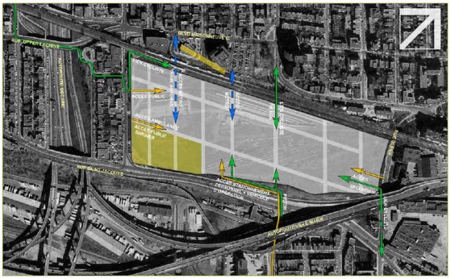
The post made me realize that I forgot to include a link to Transport Quebec’s plan for the abandoned Turcot rail yards in this site’s document list. So here it is: a 17-page document showing what the provincial government wants to do in the yards, which sit at the foot of the falaise St. Jacques.

More info about the proposal (including before and after shots) is here.

The west-end edition of The Chronicle ran a story about the falaise last week, by Martin C. Barry.

A Montreal environmental group fears that the Falaise St. Jacques — which is a densely-wooded linear green space hanging down a cliff on the south side of St. Jacques Street in NDG — could be endangered when a plan to restructure the Turcot Interchange is implemented a few years from now.

According to a brief submitted by the Green Coalition to a recent hearing of the Montreal Agglomeration’s transportation and infrastructure commission, Transport Quebec has proposed placing the Ville Marie Expressway and Canadian National’s rail line up next to the little-known Falaise.

“Presently this green area is almost inaccessible and is bombarded by the din of turbulent automotive traffic 24/7,” stated the coalition’s members. “If Highway 20 and the CNR are moved even closer, how do we square transportation policy with the public’s right to access a natural space?”

“There is no clear policy regarding the Falaise and the surrounding area,” says Avrom Shtern, a coalition member. “On the one hand, you have Transport Quebec announcing the highways and the railways being moved up close to it, and on the other hand you have Montreal announcing last year or the year before that this is a jewel that has to be protected and integrated.”

The article – click here to read the whole thing – also includes interesting comments by NDG-CDN borough mayor Michael Applebaum (who thinks the falaise would be unsafe for public use) and former local city councillor Sam Boskey (who thinks it is safe for public use).

The Sud-Ouest borough (which takes in most of the falaise) also likes the idea of turning the falaise into a park (see its 2004 proposal here).

the sound of spinning

The Westmount Examiner ran a story about the Otter Lake project last week.

It includes interesting spin from the promoters. Under their plan, Highway 20 would be moved from an industrial zone (the Turcot Yard) to the foot of the falaise St. Jacques, near a residential area in N.D.G.

Great news for N.D.G., promoter Allen F. Mackenzie told the Westmount Examiner: … “Our proposal requires the highway runs next to the falaise. This is very positive because the cliff creates a natural sound barrier for NDG residents,” Mackenzie said. …

I’ve heard it called the falaise St. Jacques, the St. Jacques escarpement and even the St. Jacques cliff. Just to confuse things, the group behind the proposal to turn the former Turcot Yards into Parc Lac à la loutre (Otter Lake Park) has taken to calling it the “Falaises Saint-Pierre,” a name La Presse repeated on the weekend.

The group has a map here that shows what it would like to see done with Turcot. The proposal would plow over parts of the falaise and cut it off from the planned park.

It proposes moving Highway 20 and remaining Canadian National train tracks to the foot of the falaise, leaving more room for the park and other developments. It also suggests cutting into the falaise to make way for roads, including one that would link Cavendish to the 20.

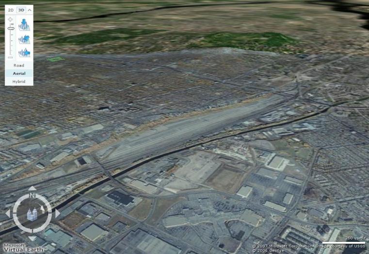
A reader wrote in to suggest I explore the falaise using Microsoft’s Visual Earth 3D (beta), which lets you look at aerial photos from an angle.

It gives an interesting perspective, with Mount Royal in the background and the Lachine canal in the foreground.  You can also see the former Turcot and Glen yards. That X at the bottom isn’t an airport, it’s Carrefour Angrignon (which, come to think of it, does feel like an airport hangar).

 visual-earth-of-falaise.jpg

You’ll have to install Virtual Earth 3D first. Go to Live Search Maps and click “Install free!” (it’s for Windows users only, of course). Once you have it installed, click here to take a look at the map at the angle I set it at above. You’ll be able to zoom in and out and roam around.

If you don’t want to install it or you have a Mac, click on the map above to take a look at a bigger version of the photo.

I got an email about the falaise from the guy who runs Cycle Fun Montreal.

Here it is:

“You might want to show a picture of the lake that used to be here or around here in the preindustrial past. I’ve seen it in at least one local history book.

My own interest would be to create Montreal’s first legal off-road bicycle trail along here. Tens of thousands of people with mountain bikes, and not a single off-road trail on the island. I am aware of the multi-user (pedestrians vs cyclists) conflicts this would create, and would hope for once that we could use some education to help both sides get along. Creating separate bicycle and pedestrian trails would be a good start.

Nice Blog.”

I haven’t seen any pictures of Otter Lake. Anybody know of one available online or in a history book?

As for mountain bike trails, I’m not sure there would be room for two trails. I don’t know much about mountain biking. Wouldn’t mountain bikes be rough on the escarpment?

I got a couple of wonderful emails from reader Dan J. Sullivan about what the area (particularly what is now de Maisonneuve Blvd. and the St. Raymond neighbourhood) was like in the 1940s and 1950s.


His first email:

“Great article. As yet I have not read the blog. As kid growing up in N.D.G. our thrill was to ride our bikes along (what is now de Maisonneuve Blvd), often a daring issue. Their then (1945-60) were some internecine wars between teenagers of different ethnic backgrounds.”


I asked for more details about the trail and the wars and he obliged:

“Herewith my best recollections:

TRAIL

This is the recollection of a retired legal professional 70+ grandfather and victim of marbles no longer as round or as sound as yesteryear. As a kid who grew up in N.D.G. on Marcil Ave. north of Monkland along with chaps the likes of which Bill Shatner, Gerald Clarke (Montreal Star), Martin Goodman (The Toronto Star), Brahm Gelfand (QC) we never thought of going below the tracks… Mon Dieu.

However, when the devil made us do it we would go (today we call it going slumming) down across Sherbrooke St and over Western Ave. (now de Maisonneuve Blvd). There was a narrow trail against the fence. The said trail would be a challenge in that it was truly very narrow and at times steep so that one could easily lose one’s balance fall close to tracks. In the event that one maneuvered through this stretch the trail meandered away from the railway into other thrills i.e. downhill into a hobo-jungle. Curiosity never led us past Montreal West.

WARS

The northern part of the tracks (a social class division used at the time) consisted, in current terminology, of “francos” and “anglos,” whilst on the southern border a lived a large contingent of first and second generation Italians.

Fixed times for a rumble would be negotiated and the two camps, armed with bats, several letter soles glued or nailed together were used for a show of strength.

These “meetings” were usually conducted in the aforementioned area (hobo-jungle) at very nocturnal hours. Since I never was invited to participate nor that I sought that experience I am unable to report what were the short or long term results of these moments in a boy’s life. Perhaps it was training for professional business careers not requiring an MBA from Harvard.

Regards,
Dan”
mysterious pipes

 A reader emailed to say those pipes sticking out of the ground on the falaise are probably “for decontamination testing. They take a core sample and leave the vent pipe to mark the spot…”

Which makes more sense than what I thought: that they were vents of some sort.

After my article about the falaise ran in The Gazette, I got an email from John Fretz, who has done some very interesting research into the St. Pierre River (the pdf is here, on the Green Coalition website).

Fretz helped fill in a few of the gaps in my falaise research:

* Fossils and calcium deposits confirm the falaise is a geological formation dating back to the Champlain Sea, he writes.

* Otter Lake definately graced the location of the Turcot interchange. “It exists on early maps of the city easily available at Westmount Library,” Fretz says. “In fact, there is a park of that name in French at the bottom of Coursol Avenue (Lansdowne), far away from the Turcot. It relates to the St. Pierre River. The last tributary of that stream flows through Meadowbrook Golf Course.”

* In the story, I mentioned I didn’t meet much wildlife. “Try early morning, or late afternoon,” he writes. “Foxes and coyotes have been spotted in the Glen Yards before the devastation.”

I brought a camera when I went for my walk. To see the pictures, click here or on the photo below.

falaise st. jacques

The article I wrote about my walk on the falaise is in today’s Gazette.

Andy Riga
The Gazette

It was an inauspicious start to a hike through a jungle in Notre Dame de Grace.

As I lost my balance and my sandalled feet slipped down the hill, I grabbed for a branch, any branch – the wrong branch, it turned out. It was covered in thorns, one of which remained wedged in my right thumb.

The good news: The searing pain – plus the scratches, bruises, mosquito swarms and fallen-tree obstacle courses to come – helped me block out the roar of Highway 20, a few hundred metres away.

My mind could focus on the mission: exploring remnants of the long-lost park of legendary Montreal mayor Jean Drapeau.

Click here for the rest.

The image “https://i0.wp.com/upload.wikimedia.org/wikipedia/en/9/9d/GardinerExpressway.JPG” cannot be displayed, because it contains errors.

That’s a photo of the Gardiner Expressway in Toronto, where advertisers can pay to have their corporate logos and brand names displayed in shrubbery by the side of the highway.

In the 1980s, an entrepreneur asked the city of Montreal to let him to do something similar on the falaise, former Montreal city councillor Sam Boskey tells me. The city turned him down.

I haven’t been able to verify this but I thought I’d throw it out there.

Avrom Shtern of the Green Coalition tells me the escarpment actually continues into Lachine:

“You can see the shale (finely stratified sedimentary rock formations) near the Highway 13 and railway yards area of what once was once called the ‘Lachine Woods.’ CN and CP built their railway yards, after World War II near that area because it was far enough to skirt Mount Royal and was on a plateau. Also, this escarpment was once at water’s edge of the inland sea called ‘The Champlain.’ Meadowbrook experiences flooding after rain storms and spring run-off because of the downward slop.”


The falaise may play a supporting role in an upcoming action movie.

From today’s Gazette:

There is also the action movie Death Race 3000, a remake of the 1970s cult favourite Death Race 2000, which has already set up shop at the Alstom Yards in Point St. Charles and is expected to shoot many of the race sequences in the abandoned Turcot Yards just off Highway 20.

It is going to be “a no-holds-barred, ultraviolent car race, set in 2020.”

It could be set on any present-day Montreal street.

muhc-path-map.jpg

Falaise path advocates suggest the bike path planned for the McGill University Hospital Centre in the old Glen rail yard should be linked to a path crossing at least part of the falaise.  

The city of Montreal is expecting the new McGill superhospital project to connect its de Maisonneuve Blvd. bike path, which ends at Decarie Blvd., with the Westmount bike path on de Maisonneuve Blvd., which begins at Claremont Ave. Currently, there’s a 400-metre gap between these two paths.

The superhospital proposal (see map above) has the Montreal de Maisonneuve path swerving on to Girouard Ave., then Upper Lachine Rd, before winding its way on to hospital grounds and making its way to Westmount.

The problem is a borough urban-planning committee doesn’t like the plan (page 4 of this PDF, and on page 7 of this PDF) because the proposed link is circuitous and includes a 20-metre-long tunnel considered unsafe.

The map is from an MUHC document that can be found in this pdf (beware, it’s a huge file).

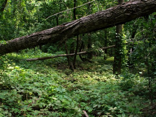
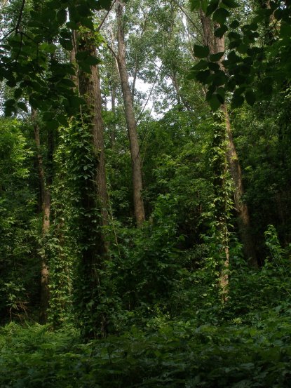
I walked the length of the falaise on Monday morning. I snapped these pics. I’ll post more next week.

lush-falaise.jpg

lush-falaise-2.jpg

mapping the falaise

mymap.jpg

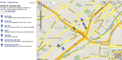
I’m working on a map using Google Maps. Click here to explore it.

the falaise dump

falaise-planting.jpg

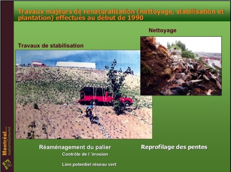
Great pictures in this city PDF, including several from the 1990s that show how much of a dump the falaise was and how barren parts of it were.

bird’s eye view

4_24.jpg

Here’s a good satellite photo showing the falaise in relation to the Glen and Turcot yards.

Yikes! I guess the chances of getting a glowing profile on the Montreal Diary page are pretty much nil.