I brought a camera when I went for my walk. To see the pictures, click here or on the photo below.
 |
| falaise st. jacques |
Posted in photos, the falaise on June 29, 2007| 2 Comments »
I brought a camera when I went for my walk. To see the pictures, click here or on the photo below.
|
| falaise st. jacques |
Posted in articles, bike paths, glen superhospital, the falaise, turcot yard on June 29, 2007| Leave a Comment »
The article I wrote about my walk on the falaise is in today’s Gazette.
Andy Riga
The Gazette
It was an inauspicious start to a hike through a jungle in Notre Dame de Grace.
As I lost my balance and my sandalled feet slipped down the hill, I grabbed for a branch, any branch – the wrong branch, it turned out. It was covered in thorns, one of which remained wedged in my right thumb.
The good news: The searing pain – plus the scratches, bruises, mosquito swarms and fallen-tree obstacle courses to come – helped me block out the roar of Highway 20, a few hundred metres away.
My mind could focus on the mission: exploring remnants of the long-lost park of legendary Montreal mayor Jean Drapeau.
…
Click here for the rest.
Posted in the falaise on June 28, 2007| 2 Comments »

That’s a photo of the Gardiner Expressway in Toronto, where advertisers can pay to have their corporate logos and brand names displayed in shrubbery by the side of the highway.
In the 1980s, an entrepreneur asked the city of Montreal to let him to do something similar on the falaise, former Montreal city councillor Sam Boskey tells me. The city turned him down.
Posted in the falaise on June 28, 2007| 1 Comment »
I haven’t been able to verify this but I thought I’d throw it out there.
Avrom Shtern of the Green Coalition tells me the escarpment actually continues into Lachine:
“You can see the shale (finely stratified sedimentary rock formations) near the Highway 13 and railway yards area of what once was once called the ‘Lachine Woods.’ CN and CP built their railway yards, after World War II near that area because it was far enough to skirt Mount Royal and was on a plateau. Also, this escarpment was once at water’s edge of the inland sea called ‘The Champlain.’ Meadowbrook experiences flooding after rain storms and spring run-off because of the downward slop.”
Posted in the falaise, turcot yard on June 25, 2007| 1 Comment »

The falaise may play a supporting role in an upcoming action movie.
From today’s Gazette:
There is also the action movie Death Race 3000, a remake of the 1970s cult favourite Death Race 2000, which has already set up shop at the Alstom Yards in Point St. Charles and is expected to shoot many of the race sequences in the abandoned Turcot Yards just off Highway 20.
It is going to be “a no-holds-barred, ultraviolent car race, set in 2020.”
It could be set on any present-day Montreal street.
Posted in bike paths, glen superhospital, reports, the falaise on June 22, 2007| Leave a Comment »

Falaise path advocates suggest the bike path planned for the McGill University Hospital Centre in the old Glen rail yard should be linked to a path crossing at least part of the falaise.
The city of Montreal is expecting the new McGill superhospital project to connect its de Maisonneuve Blvd. bike path, which ends at Decarie Blvd., with the Westmount bike path on de Maisonneuve Blvd., which begins at Claremont Ave. Currently, there’s a 400-metre gap between these two paths.
The superhospital proposal (see map above) has the Montreal de Maisonneuve path swerving on to Girouard Ave., then Upper Lachine Rd, before winding its way on to hospital grounds and making its way to Westmount.
The problem is a borough urban-planning committee doesn’t like the plan (page 4 of this PDF, and on page 7 of this PDF) because the proposed link is circuitous and includes a 20-metre-long tunnel considered unsafe.
The map is from an MUHC document that can be found in this pdf (beware, it’s a huge file).
Posted in photos, the falaise on June 20, 2007| 2 Comments »
I walked the length of the falaise on Monday morning. I snapped these pics. I’ll post more next week.


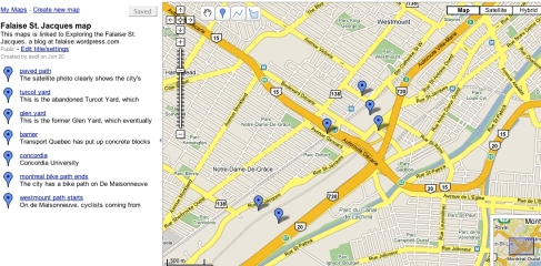
Posted in maps, the falaise on June 20, 2007| Leave a Comment »
Posted in photos, reports, the falaise on June 20, 2007| 1 Comment »

Great pictures in this city PDF, including several from the 1990s that show how much of a dump the falaise was and how barren parts of it were.
Posted in maps, photos, the falaise on June 20, 2007| Leave a Comment »

Here’s a good satellite photo showing the falaise in relation to the Glen and Turcot yards.
Posted in the falaise on June 20, 2007| 3 Comments »
Yikes! I guess the chances of getting a glowing profile on the Montreal Diary page are pretty much nil.
Posted in maps, the falaise on June 19, 2007| 1 Comment »

The falaise St. Jacques is a geological formation that dates back to the Champlain Sea, which covered much of the Montreal area after the last ice age more than 10,000 years ago.
Natural Resources Canada has a fascinating animated graphic showing Montreal emerging from that sea. Click here for the explanation and here for the animated graphic.
Posted in bike paths, reports, the falaise on June 19, 2007| Leave a Comment »
In May 2004, the Sud-Ouest borough presented a detailed plan on what to do with the falaise to the Office de consultation publique de Montréal. (The pdf is here, the HTML version here).
Essentially, they suggest the area be cleaned up, stabilized and turned into a linear park/bike path connecting the Sud-Ouest down below to Notre Dame de Grâce at the top.
Posted in discussions, the falaise on June 19, 2007| Leave a Comment »
There was an interesting discussion here about the falaise and Montreal West (on Walking Turcot Yards).
Posted in the falaise on June 19, 2007| 5 Comments »

Tens of thousands of Montrealers drive past the falaise St. Jacques every day and the city has declared it one of its “eco-territoires” (see pdf here) but few of us know very much about the unusual, long strip of greenspace.
This blog is about my research into its history and the various ideas about what to do with it.